The "Applied Ecology and Remote Sensing" research unit conducts experimental activities in the field of plant ecophysiology and remote sensing focusing on the analysis of plant communities.
Vegetation plays a fundamental role in shaping ecosystems’ structure and functioning. Quantifying the different facets of biodiversity (taxonomic, functional, and phylogenetic) is essential for monitoring plant communities and estimating their response to the effects of climate change. Generally, these facets are quantified through sampling campaigns, which are often costly in terms of time and resources and spatially limited. Recent technological advances in the field of remote sensing provide a viable alternative to traditional sampling methods, as recent studies have demonstrated the possibility of estimating taxonomic, functional, and phylogenetic diversity through the analysis of images (both multi- and hyper-spectral) remotely sensed by satellite or drone.
The research group is mainly concerned with:
- Analysis of the relationships between morpho-anatomical and physiological functional traits of plant communities;
- Analysis, monitoring and quantification of taxonomic, functional and phylogenetic diversity of plant communities through the analysis of remotely-sensed satellite and drone images;
- Quantification of functional parameters at the individual and community levels through the analysis of high-resolution remote sensing drone imagery in controlled experiments;
- Monitoring agroforestry systems at the regional level from remote.
The use of remote sensing tools, both satellite and airborne, allows the measurement of the spectral response of plant communities at different spatial and temporal scales. The recent development of proximal remote sensing using small drones (SAPRs) has opened new perspectives for the study of biodiversity, and in particular for the quantification of different vegetation facets. Based on the high spatial, radiometric, and spectral resolution images acquired from a drone or a satellite, it is possible to obtain detailed information on plant communities, including those occurring in areas that are not easily accessible. By using special sensors mounted on satellites and drones, it is possible to acquire multispectral and hyperspectral images that provide important information for vegetation analysis and monitoring.
The goal of the research unit is to deepen our knowledge on the relationships between taxonomic, functional and phylogenetic aspects of plant communities through an integrated interdisciplinary approach of fieldwork and remote sensing, from the scale of individuals to that of plant populations, communities and landscape.
Our main research lines currently include:
1. Integrating plant hydraulic traits into the major trade-offs between functional traits used to describe plant functional diversity
A major goal in the study of plant functional diversity is to understand the fundamental trade-offs among functional traits that underlie plant ecological strategies. Several trade-offs have been described in the "Leaf Economic Spectrum" (LES), allowing to distinguish species according to an "acquisitive-conservative" gradient. According to the LES, it is possible to distinguish between species with a conservative strategy (i.e., investing more resources in the construction of leaves, which have a longer lifespan at the expense of slower growth) vs species with an acquisitive strategy (i.e., growing faster due to reduced leaf construction costs, but being more vulnerable when growth conditions are not optimal). However, only functional traits related to carbon and nutrient use and acquisition have generally been considered in this type of analyses, while hydraulic functional traits (i.e., related to drought resistance and water-use efficiency) have been poorly included in large-scale studies. In this light, our laboratory performed several studies in different areas characterized by different environmental conditions (from coastal dunes to wetlands in central and northeastern Italy), where LES, hydraulic and leaf venation traits have been measured on the most abundant plant species. The main objective is to highlight whether water-related traits describe a variation axis independent of that described by LES in the multidimensional space generated by functional traits. Our analyses suggest that traits related to drought resistance and leaf hydraulic efficiency could capture additional information to describe the functional spaces underlying plant ecological strategies.
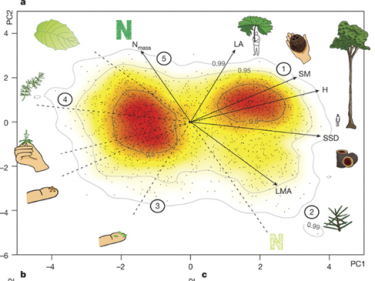
Source: Diaz et al. 2016 Nature
2. Study of the relationship between taxonomic, functional and spectral diversity of plant communities.
In recent decades, climate change has accelerated rapidly, adversely affecting human society and natural environments, especially the most dynamic ones. For this reason, analysing and quantifying the taxonomic and functional composition of plant communities is essential to monitor the effects of climate change on ecosystem functioning. Generally, field activities are required to quantify the taxonomic and functional diversity of one or more communities. However, sampling activities are often time- consuming and expensive. As an alternative approach, remote sensing could provide valuable information on plant communities and their functional composition, through the analysis of multi- and hyper-spectral images obtained by satellites or drones. The main activities of our research group aim at analysing the relationships between taxonomic, functional and spectral diversity through studies performed under controlled conditions, as well as through field studies at different spatial scales (from that of individual communities to whole ecosystems).
The following are the main active projects:
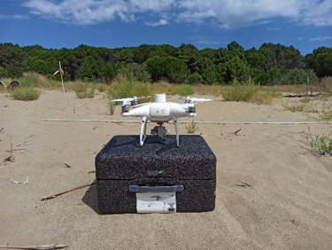
2.1 Controlled experiments to estimate functional traits related to resource use and utilization of woody plant species through multi- and hyper-spectral images obtained by a drone
The use of remote sensing techniques could revolutionize the ability to quantify biodiversity in space and time. A growing number of studies have explored the applicability of remote sensing techniques in predicting the functional traits of plant species, using both satellites and unmanned aerial vehicles (e.g., drones) equipped with multispectral or hyperspectral sensors. These instruments can measure the reflectance of an object in specific regions of the electromagnetic spectrum (EM, i.e., spectral bands). Multispectral sensors usually have 3 to 15 spectral bands, while hundreds of spectral bands may be available in hyperspectral ones. The main objective of this project is to test the ability to predict leaf morpho-logical and physiological functional traits based on spectral reflectance in the visible/near infrared (NIR) measured with multispectral and hyperspectral sensors mounted on a drone. In this light, we set up a controlled experiment on 4 plant species (Pinus nigra, Quercus ilex, Quercus pubescens, Fagus sylvatica) in the Botanical Garden of the University of Trieste.

2.2 Quantification of taxonomic and functional composition of psammophilous vegetation through multispectral images obtained with a drone
Coastal dune ecosystems are dynamic environments strongly impacted by climate change, which has caused rapid biodiversity loss, increased abundance of invasive exotic species, and changes in community assembly processes. With this in mind, optical remote sensing could provide a new method for quantifying and monitoring the functional composition of psammophilous vegetation at large spatial and temporal scales. Specifically, it is possible to estimate both individual functional traits of species or communities and more complex indices of functional diversity from remote. In our laboratory, we tested the possibility to estimate (using a drone equipped with a multispectral camera) the taxonomic and functional composition of coastal dunes from remote. The main goal of this research activity is to: i) highlight the relationships between physiological functional traits and the spectral response of psammophilous species and ii) to identify the most robust methods to estimate the relationship between taxonomic, functional and spectral diversity of plant communities typical of these ecosystems.
2.3 Analysis of the relationships between taxonomic, functional and spectral diversity at the regional scale
Spectral diversity (SD), defined as the diversity in reflectance values, can be used to estimate plant taxonomic diversity (TD), following the so-called "spectral variability hypothesis" (SVH). However, contrasting relationships between SD and TD have been found in several studies using a wide range of sensors, methodologies, and diversity indices in different habitats. Indeed, multiple factors may influence SD, including spatial and spectral resolutions, environmental characteristics of the study area, vegetation cover and structure, or the SD calculation method adopted. In addition, a growing number of studies have explored the applicability of remote sensing techniques to quantify plant functional diversity (FD) in different ecosystems. Recent technological advances and the launch of high spatial and spectral resolution sensors into orbit have increased the potential of satellites to estimate FD remotely. Nevertheless, further studies are needed to develop appropriate quantitative methods to quantify FD using satellite observations. Through the analysis of images obtained by high spatial (World-View) and spectral (Sentinel-2, PRISMA) resolution satellites, we have started two research projects aiming at: i) identifying possible factors influencing the strength and direction of the relationship between SD and TD, and ii) identifying the most robust methods to quantify the relationship between SD and FD.
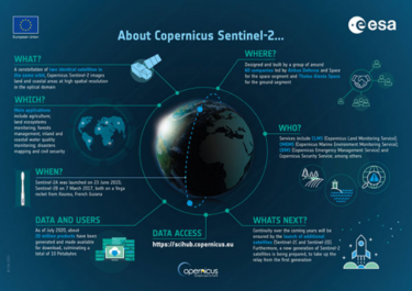
Source: ESA website (European Space Agency, www.sentinel.esa.int)
3. Use of remote sensing satellite imagery to estimate the risk of fire spread in Karst.
Wildfires are a main natural factor influencing vegetation structure. However, their excessive frequency can threat ecosystems leading to a loss of biodiversity, ecosystem services as well as a potential danger to human infrastructure. Climate change is inducing, in many areas of the planet, an increase in average temperatures and a decrease in precipitation. These two factors combined with changes in land use can increase the frequency of wildfires. The frequency of wildfires in Europe in summer 2022 was exceptional in terms of the extent and number of fires observed. According to the European Forest Fire Information System (EFFIS), from June to mid-August 2022, the number of fires detected in Europe was higher than the average in 2006-2021 time period. The most affected countries were France, Spain, Portugal, and Italy. In Italy, the Karst region was one of the most affected by wildfires, which damaged large areas over the summer season. Our research group has started a project aiming at estimating the risk of fire spread in the Karst area affected by wildfires occurred in 2022 through the analysis of satellite remotely-sensed images.
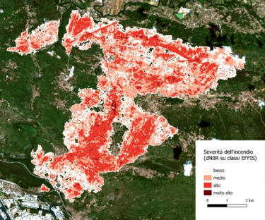
Source: Università degli Studi di Udine
4. Monitoring agro-forestry systems in Friuli-Venezia Giulia region from remote.
Ongoing climate change poses serious risks to the health and productivity of various agro-ecosystems globally. In this light, developing continuous monitoring systems in time and space to track the phenological development of vegetation become fundamental to identify crops in agricultural fields, their turnover, and quantify key plant biophysical parameters. Remote sensing is recognized as one of the most effective methods to address this objective. Indeed, the advances made in this field and the resources made freely available by the Copernicus project and other programs, allow to obtain simultaneous information for areas of considerable size, both at regional and global scales. Indeed, there are several studies that have demonstrated the effectiveness of remote sensing in quantifying various parameters of both vegetation (e.g., growth and productivity, biomass, photosynthesic rate, water status) and soil (e.g.,soil temperature and moisture). Our research unit has started a project in collaboration with Friuli-Venezia Giulia (FVG) Region aim at developing a continuous monitoring system of FVG region by taking advantage of innovative technologies offered by remote sensing. The development of such system may offer various agro-environmental applications (e.g., crops and soil management practices identification, crops and soil biophysical parameters estimation), and will likely be a tool to support future management of agroforestry systems.